GeoNames extractors
| Line 20: | Line 20: | ||
|- | |- | ||
| Country info | | Country info | ||
| − | | | + | | Reads country information from GeoNames database. Country name is selected from drop down menu. Optionally user can write country name or multiple country names to the field. Special keyword '''ALL''' reads information for all known countries. If user has already performed GeoNames extractions or has country name available in topic for some other reason, user can pick up the country name from context topics. |
|- | |- | ||
| Cities | | Cities | ||
| − | | | + | | Reads cities in given bounding box from GeoNames database. Bounding box has four different geographical coordinates: |
| + | |||
| + | * north edge, | ||
| + | * west edge, | ||
| + | * south edge, | ||
| + | * east edge | ||
| + | |||
| + | If user has already performed GeoNames extractions and has suitable topic selected, Get context button reads available coordinates from the topic. For example, Country info extraction sets bounding box for each country topic, and user could use this bounding box to continue extracting cities of the country. | ||
|- | |- | ||
| Children | | Children | ||
Revision as of 14:10, 11 December 2008
GeoNames is a very large networked database of geographical locations and related data. GeoNames contains over eight million geographical names and 6.5 million unique features. GeoNames database is available for free of charge under a creative commons attribution license. GeoNames has a web service api with various different query types.
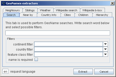
Wandora's GeoNames extractor performs GeoNames web service api requests and converts results to topic maps formats. Wandora is a graphical front end to GeoNames web service api, if you like. Extractor starts with menu option File > Extract > GeoNames extractor.... Current extractor has several options as image below views. By default extractor performs free text search to GeoNames geographical database.
Available extractors are
| Tab | Description |
| Search | Performs free text search to GeoNames database. User may filter result set with optional continent, country, and feature class filters. All filters are selected using drop down selection. User can also require the search term is part of the place name. |
| Near by | Performs coordinate search to GeoNames database. User gives extractor latitude and longitude coordinate, radius in kilometers, and optional feature class. Result set contains geographical location in specified area. If user has already performed GeoNames extractions and has selected one geo-topic with latitude and longitude coordinates, user can get coordinates from the context topic. |
| Country info | Reads country information from GeoNames database. Country name is selected from drop down menu. Optionally user can write country name or multiple country names to the field. Special keyword ALL reads information for all known countries. If user has already performed GeoNames extractions or has country name available in topic for some other reason, user can pick up the country name from context topics. |
| Cities | Reads cities in given bounding box from GeoNames database. Bounding box has four different geographical coordinates:
If user has already performed GeoNames extractions and has suitable topic selected, Get context button reads available coordinates from the topic. For example, Country info extraction sets bounding box for each country topic, and user could use this bounding box to continue extracting cities of the country. |
| Children | |
| Heirarchy | |
| Neighbours | |
| Siblings | |
| Weather | |
| Wikipedia search | |
| Wikipedia b-box |
Country Info
Cities
Children


